Is the sand in front of a Gig Harbor home really yours, or does the state own it? If you are buying or selling on the harbor, that question is more than trivia. It can shape your right to moor a boat, keep a dock, or even where your true property line sits. In this guide, you will learn how tidelands work in Washington, what the ordinary high water mark means, and the steps to verify rights before you commit. Let’s dive in.
Tidelands in Gig Harbor, at a glance
Gig Harbor’s shoreline is tidally influenced. In Washington, the state generally holds the beds and submerged lands of navigable tidal waters in trust for the public. The Washington Department of Natural Resources manages many of these aquatic lands. Some tidelands, however, were historically conveyed to private parties, which means private ownership does exist in places.
Owning an upland parcel in Gig Harbor does not automatically include the beach or seabed below the high-tide line. Whether tidelands are state-owned or private depends on your deed, historical patents, recorded plats, and legal boundaries tied to waterlines.
State ownership vs. private grants
• The state presumes ownership of submerged lands unless a valid, recorded conveyance says otherwise. The DNR oversees these public aquatic lands and authorizes uses like moorage through leases or permits.
• Private tidelands are the exception and stem from historical state patents or grants. Confirming private ownership requires careful deed and title research.
The role of DNR
If structures or moorage extend over state-owned seabed, you typically need authorization from the Washington Department of Natural Resources. Start with the DNR’s overview of aquatic lands to understand how ownership and leasing work across the state. You can explore DNR guidance on aquatic lands management by reviewing the agency’s Aquatics program materials at the Washington Department of Natural Resources.
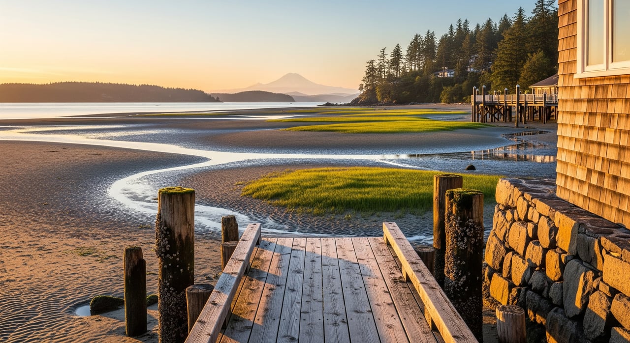
Where your boundary likely ends
Ordinary High Water Mark, explained
The ordinary high water mark, often called the OHWM, commonly separates private uplands from state-owned aquatic lands. If your deed says your property runs to the “high water mark,” everything landward of that line is typically private, while seaward areas are often public unless the state conveyed them.
Locating the OHWM is a field exercise. A licensed land surveyor with tidal experience uses physical evidence such as vegetation, debris lines, and historical records to determine it. Many standard surveys do not include an OHWM. If you are buying on the harbor, request a survey that specifically calls out the OHWM.
When shorelines move: accretion, erosion, avulsion
Shorelines change over time, and the law treats gradual and sudden changes differently.
• Accretion is gradual buildup of land. Title commonly follows the new shore.
• Erosion is gradual loss of land. Title typically recedes with the shoreline.
• Avulsion is a sudden, perceptible shift, such as after a major storm or artificial cut. In avulsion, the legal boundary usually stays where it was.
Sorting out which process occurred relies on evidence like surveys, aerial photos, and historical records. For complex cases, you may need both survey and legal review.
How tidelands affect docks and moorage
When you need a DNR lease
If the seabed beneath your dock, pier, float, or mooring buoy is state-owned, you generally need DNR authorization. Some docks were built under older permits; others may lack documentation. During a sale, request copies of any DNR lease, lease transfer paperwork, and expiration or renewal terms. Learn how leases and permits function in Washington by reviewing DNR’s aquatics pages at the Washington Department of Natural Resources.
Permits you may need
Beyond DNR authorization, multiple layers of permits can apply to docks, bulkheads, and fills:
• Washington Department of Ecology administers the Shoreline Management Act and local Shoreline Master Programs. Review shoreline rules at the Washington Department of Ecology.
• The U.S. Army Corps of Engineers regulates structures in navigable waters, often under Section 10 and 404. See the regulatory overview from the U.S. Army Corps of Engineers.
• City of Gig Harbor and Pierce County administer local shoreline permits, setbacks, and critical area requirements. You can explore local planning guidance at the City of Gig Harbor Planning and Building and Pierce County Planning and Public Works.
Even if you own to a particular boundary, you may still need these approvals for construction, repair, or maintenance.
What to look for in a transaction
Red flags in title and surveys
Title commitments often include exceptions for state-owned lands or tidelands when property abuts tidal waters. Look for deed language that stops at the high water mark or mentions reservations or patents. Ask the title company to explain whether the policy will insure tidal boundaries or exclude them.
On the survey, watch for notes like “OHWM not located.” That may mean more fieldwork is needed. A survey that shows the OHWM, improvements, and any encroachments is an important tool for waterfront due diligence.
Common scenarios in Gig Harbor sales
• Waterfront listing excludes the seabed. You may still access the water, but new moorage could require DNR authorization.
• Older dock with limited paperwork. Without proof of authorization, you risk future enforcement or the need for a retroactive lease.
• Shoreline changes since the deed. If change was gradual, boundaries may have moved; if sudden, they probably did not. Evidence matters.
• Apparent yard meets state tidelands. The visible beach can be public aquatic land, which affects use and improvements.
Step-by-step verification checklist
Use this sequence to surface issues early and protect your timeline.
- Gather records
• Current deed and full chain of title.
• Any patents, grants, reservations, or recorded DNR leases.
• Prior surveys. If none or outdated, plan an updated boundary survey with OHWM determination.
• Title commitment showing exceptions related to state-owned lands.
• Copies of shoreline permits and approvals for docks, bulkheads, fills, and any USACE permits.
• Seller disclosures about shoreline disputes or enforcement.
- Engage the right professionals
• Licensed land surveyor with tidal experience to locate the OHWM and map boundaries.
• Real estate attorney to interpret deed and patent language, and advise on title exceptions.
• Title company to clarify what the policy will and will not insure for tideland boundaries.
• DNR staff for aquatic-land title and lease records; Ecology for shoreline permit history; City of Gig Harbor or Pierce County for local code and permits.
• Marine contractor or dock builder for moorage feasibility and condition assessments. Consider a coastal or geomorphology expert for complex shoreline change.
- Use contingencies in your offer
• Survey contingency that specifically calls for OHWM determination and states who pays.
• Title contingency to review tideland-related exceptions and obtain DNR records.
• Permit contingency to confirm validity and transferability of dock leases and permits.
• If needed, require a DNR aquatic-land title report or an attorney opinion before closing.
- Negotiate with clarity
• Seek price adjustments if authorization risk or nonconforming structures reduce utility.
• Require the seller to cure title or permit defects, or to provide evidence of valid DNR authorization.
• Allocate costs for updated surveys, lease transfer fees, or compliance steps.
Local contacts and records
For authoritative answers and parcel-specific records, start here:
• Washington Department of Natural Resources for aquatic lands ownership and leasing: Washington Department of Natural Resources
• Washington Department of Ecology for Shoreline Management Act and SMP guidance: Washington Department of Ecology
• U.S. Army Corps of Engineers for federal permitting: U.S. Army Corps of Engineers
• City of Gig Harbor planning and permits: City of Gig Harbor Planning and Building
• Pierce County planning, shoreline rules, and public records: Pierce County Planning and Public Works
• Pierce County property and recording portals: Pierce County Assessor-Treasurer and Pierce County Auditor
Final thoughts
In Gig Harbor, tideland rights influence much more than a shoreline’s edge. They affect your ability to moor a boat, maintain a dock, and secure permits. The smartest move is to verify early. Ask for deed and permit records, commission a survey that locates the OHWM, review title exceptions closely, and engage with DNR and local planning staff when moorage or structures are involved.
If you would like a discreet, step-by-step plan tailored to your property or purchase, our team can coordinate survey, title, and permitting reviews with the right specialists. For refined guidance on Gig Harbor waterfront, connect with Morrison House Sotheby’s International Realty®.
FAQs
What are tidelands in Washington?
- Tidelands are the beds and submerged lands of navigable tidal waters that the state generally holds in trust unless they were historically conveyed to private owners.
How do I know if I own the beach in front of my Gig Harbor home?
- Check deed language and patents, obtain a title commitment, and have a surveyor determine the OHWM to see whether seaward areas are state-owned or private.
Do I need a DNR lease to keep my dock in Gig Harbor?
- If your dock sits over state-owned aquatic land, you typically need DNR authorization; request copies of any existing lease and confirm transfer terms during a sale.
What is the Ordinary High Water Mark and who determines it?
- The OHWM is a shoreline benchmark that commonly separates private upland from public aquatic land, and a licensed surveyor experienced with tides determines it in the field.
How does shoreline change affect my Gig Harbor property line?
- Gradual change through accretion or erosion often moves the boundary, while sudden avulsion typically does not; evidence and expert review are key.
What records should I request when buying Gig Harbor waterfront?
- Ask for the deed and chain of title, title commitment, prior surveys, DNR leases, shoreline and USACE permits, and seller disclosures regarding shoreline issues.